SPACE SURVEILLANCE
Over the past 35 years the United States has deployed a wide range of systems for monitoring the space activities of other countries.
(1) For the most part, the primary mission of these sensors has been to provide warning of strategic missile attack. But the growing number of satellites in orbit has increased the requirement to keep track of new launches and impending decays of satellites, in order to avoid confusing these events with hostile missile launches. In addition, the increasing importance of military space operations has made the tracking and characterization of space systems a significant mission in its own right.
Satellite tracking systems, both optical and radar, are among the most sophisticated and expensive military sensor technologies. Spacetrack radars typically have ranges and sensitivities ten to a hundred times greater than radars for tracking aircraft or surface targets. And optical tracking systems use telescopes that rival all but the largest civilian astronomical observatories. A modest satellite tracking radar or telescope typically costs a few tens of millions of dollars, while the more elaborate radars can cost well in excess of $100 million.
The earliest, and still the least expensive, form of satellite tracking systems rely on sun light reflected off a spacecraft. Visible against the pre-dawn or post-dusk sky, the largest low orbiting spacecraft, such as space stations or imaging intelligence satellites, are of magnitude 0, comparable to the brighter stars in the sky, and many other low-orbiting satellites are visible to the unaided observer.
(2) Even satellites at geosynchronous altitudes are visible with relative modest optics, under optimal lighting conditions.
(3)
The capabilities of telescopes to observe satellites is primarily a function of the aperture of the primary optical surface of the telescope, as well as the properties of the means used to form the image. Telescopes with mirrors up to four meters in diameter have been used for satellite tracking, while telescopes with meters in excess of eight meters in diameter are used for astronomical applications. Initially, satellite tracking cameras used film systems, but more recently electronic charge-coupled devices (CCDs) have replaced film systems. CCDs provide an instantaneous read-out of the image, avoiding the time-consuming processing required by film systems. These electronic cameras have enabled scientific telescopes of modest apertures of a few meters to obtain recognizable images of large spacecraft in low orbits.
(4)
The primary limitation on the resolution of ground-based optical sensors is the turbulence of the Earth's atmosphere. Recently, two new techniques have been introduced to overcome these limitations. Speckle imaging techniques take advantage of the short exposure time of CCDs to produce images of targets with exposure times that are shorter than the time scale of the fluctuations in the Earth's atmosphere, effectively freezing the effects of atmospheric turbulence. Electronically superimposing a number of such images produces a picture of a satellite whose resolution is limited by the capabilities of the telescope itself.
(5)
Several other developments in recent years have opened the prospect for greatly improved optical imaging capabilities at significantly reduced costs. New techniques for casting thin mirrors have led to a revolution in optical astronomy, with monolithic mirrors as large as eight meters being produced at significantly lower cost than the four meter mirror that were previously the astronomical standard. Improved construction and control techniques have permitted fabrication of single-aperture telescopes with apertures of up to ten meters. And new aperture synthesis signal processing techniques have permitted the combination of images from multiple apertures to form images that are the equivalent of telescopes with apertures of many dozens of meters.
Although most optical sensors rely on reflected sunlight or emitted infrared energy for satellite tracking, active optical sensors are finding increasingly application. By illuminating a target with coherent laser radiation, these systems can image satellites that are not illuminated by sunlight at night, as well as targets that may be obscured by sky-glow during daylight hours. The use of active illumination also permits direct measurement of the range to the target, as well as facilitating characterization of the satellite's structure.
Ground-based radar systems have been used since the late 1950s to track civilian and military satellites.
(6) Radars have several advantages over optical tracking systems, including the ability to observe targets 24 hours a day, and during cloudy or overcast conditions. Today the United States and the Commonwealth of Independent States both deploy extensive networks of radars which perform the satellite tracking function, as well as other duties, such as detection of missile attack. The performance of a radar is a function of the range to the target and the target's size or radar cross-section, as well as the radar's transmitting frequency and power, and the diameter of the transmitting antenna. Radars used for the initial detection of targets typically are able to locate an object with an accuracy of about 1,000 meters, while tracking radars have accuracies of from 10 to 300 meters.
(7)
As radar technology has advanced, the problem has taken on a new dimension. Today's modern and sophisticated large phased array radars (LPARs) can serve many functions. They can provide early warning of missile or bomber attack. LPARs can track satellites and other objects in space and observe missile tests to obtain information for monitoring purposes. They are also an essential component of present generation ABM systems, providing initial warning of an attack and battle management support, distinguishing RVs from decoys, and guiding interceptors to their targets. In some cases, distinguishing an LPAR designed for one of these functions from one designed for an ABM role can be rather difficult.
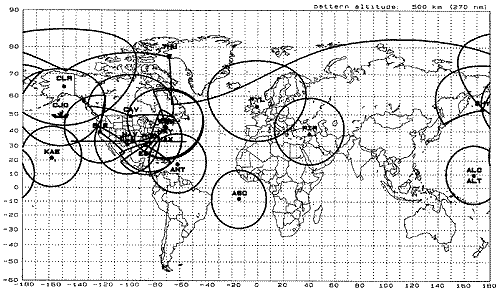
Space Surveillance Network Radar Sensors and Field of View at 500 km Altitude
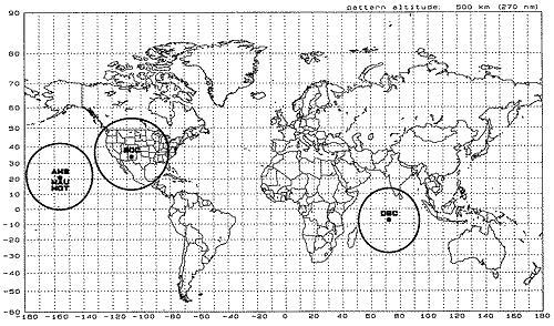
Space Surveillance Network Optical Sensors and Field of View at 500 km Altitude
 A - Navy
12427N Naval Space Surveillance System - NAVSPASUR(8)
A - Navy
12427N Naval Space Surveillance System - NAVSPASUR(8)
The Naval Space Surveillance (NAVSPASUR) System is an integral component of the
US Space Command Detection and Tracking System, providing continuous surveillance and unalerted detection of space objects crossing the continental United States. NAVSPASUR is also the only space surveillance system which provides satellite vulnerability data to fleet units. It is a multistatic continuous-wave radar fence consisting of three transmitter sites, six receiver sites, and a computational center. The transmitter and receiver sites are located in a great circle across the southern US, and the computational center is located at NAVSPASUR headquarters in Dahlgren, VA. Includes personnel authorizations, peculiar and support equipment, necessary facilities and the associated costs specifically identified and measurable to SPASUR Headquarters Receiving Stations Transmitting Stations.
Recent activities include the upgraded Digital Receiver Replacement (DDR) and the Digital Filter Replacement (DFR).
Work is performed by the
Naval Research Laboratory (NRL), Washington, DC.
12428N Space Surveillance (SPASUR) - Communications(9)
Includes personnel authorizations, peculiar and support equipment, necessary facilities and the associated costs specifically identified and measurable to communications subsystems supporting the Naval Space Surveillance System, i.e., SPASUR headquarters, receiving stations, and transmitting stations. Excludes all leased communications identified and reported in Program 3.
B - Air Force
12310F NCMC TW /AA Systems(10)
Includes resources (personnel authorizations, research and development, investment, operations and maintenance) that support the NORAD Cheyenne Mountain Complex (NCMC) ballistic missile and atmospheric tactical warning attack assessment (TW/AA) missions. Includes ADP resources for existing NCMC TW/AA systems; related systems installed in the off-site Test Facility and Test, Development and Training; Center and programmed replacements for the Communications System Segment and NORAD computer System. Also includes those resources devoted to planning, designing, developing, procuring, leasing, programming, and operating NCMC TW/AA systems. Excludes any resources associated with the intelligence data handling system (PE 31334F), NCMC space defense systems (PE 12311F), NCMC communications support (PE 12323F), and resources associated with WWMCCS-Standard and WIS ADP programs.
12311F NORAD Cheyenne Mountain Complex CMC
12311F NCMC Space Defense Systems(11)
Includes resources personnel authorizations , research and development , investment , operations and maintenance) that support the NORAD Cheyenne Mountain Complex (NCMC) space surveillance and space defense missions. Includes ADP resources for existing;l NCMC space surveillance/defense systems related systems installed in the Off-Site Test Facility and Test, Development, and Training Center; and programmed replacements/upgrades for the SPADOC, SPADOC Computational Center and Mission operations Center. Also includes those resources devoted to planning/ designing developing, procuring, leasing; , programming and operating space surveillance and space defense systems to include ASAT C2 systems. Excludes any resources associated with the intelligence data handling systems (PE 31334F), NCMC ballistic missile and atmospheric tactical warning/attack assessment systems (PE 12310F), NCMC communications support (PE 12323F) and resources associated with WWMCCS-standard and WIS ADP programs.
Shemya COBRA DANE
The Cobra Dane is an L-band (1175-1375 MHZ) LPAR at Shemya Island, Alaska, with a maximum range of 5,500 kilometers. It is capable of tracking over 200 objects simultaneously, and can locate an object 10 centimeters in diameter at a range of nearly 4,000 kilometers with an accuracy of 5 meters.
12313F Ballistic Missile Tactical Warning/Attack Assessment System(12)
This PE provides for Ballistic Missile Tactical Warning/Attack Assessment (TW/AA) resources which extend across multIple subsystem/commands and apply to the System as an entity. Resources include a newly established (FY 81) System Integration Office (SIA) providing (TW/AA) System architecture,TW/AA and collateral systems interface/integration engineering, configuration control, data management, TW/AA System interface/integration test and demonstration,TW/AA evaluation analysis and Collateral Sensor Support. SIA resources are for the following functions; either directly or through coordination with other Commands/Agencies.
a. Establish and maintain the TW/AA System configuration baseline. b. Perform interface/integration engineering and testing. c. Establish, verify and evaluate technical integrity among specified operational TW/AA requirements, component operational capabilities, TW/AA System architecture and capabilities , and the approved/proposed programs and enhancements. Includes establishing hardware and software configurations. d. Provide technical guidance to support the analysis and evaluation of the TW/AA system. The system must evolve to meet new threats, new missions, resource allocation changes, policy and doctrine changes , and technological and environmental changes. e. Provides a coherent interface and architecture design. f. Translate operational TW/AA requirements into functional engineering requirements. 9. Evaluate and propose sensor cross-checks and interoperabllity with Command Centers. h. Identify, organize, and manage interrelated technical roles available from. several engineering disciplines to satisfy overall TW/AA systems engineering design requirements. i. Provide a common technical reference baseline for communications among TW/AA user organizations, between TW/AA users and developers, and among developers.i. Plan, design, develop and publish technical engineering standards, procedures, and interface/integration criteria for TW/AA System components and monitor adherence to such standards. k. Provide PPBS inputs to the Aerospace Defense t::enter as required and monitor R&D efforts that have impact on the TW/AA System. It will certify compatibility of all TW/AA components, both existing and newly developed.
12323F NORAD COC Communications(13)
Includes resources /personnel authorizations, research and development, investments, operations and maintenance) that provide DCS and non-DCS strategic connectivity between ballistic missile tactical warning/attack assessment (TW/AA) sensor sites and key command centers (NORAD/ SAC/ and NCA ground facilities). Includes personnel to operate and maintain TW/AA communications facilities and resources to lease, develop, procure and maintain dedicated commercial and military communications systems (circuits, line termination equipment) that support TW/AA data, teletype and voice connectivity requirements. Also provides resources for sensor and command center interfaces with programmed survivable communications systems (JRSC/ GWEN/ MILSTAR/ etc.). Excludes any resources associated with the AF COMSEC Program PE 33401F), common user communications networks such as AUTOVON and AUTODlN PE 33126F), base level communications PE 33112F) and major military communications systems such as DSCS PE 33110F). Also excludes resources associated directly with TW/AA sensors and the NORAD Cheyenne Mountain Complex.
12414F Spacetrack Proj 2295 GEODSS
The
Ground-based Electro-Optical Deep Space Surveillance (GEODSS) network of sophisticated telescopes using reflected visible light, track objects as small as one square meter, reflecting only 10% of incident sunlight, in orbits at altitudes from 3,000 to 35,000 kilometers.
(14) Each installation consists of two telescopes with 1 meter diameter optics for high-altitude search, as well as a single telescope with a 0.4 meter aperture for tracking lower altitude objects.
(15) The videcon electro-optical sensors on these systems are capable of tracking up to 200 object per night. This system can scan the sky for new satellites 100 times faster than the previous Baker-Nunn film cameras. A total of five sites are planned, at a total cost of approximately $250 million.
(16) White Sands, NM, Maui, HI, Taegu, Korea, were completed in 1983, with Diego Garcia, in the Indian Ocean, completed in 1987. An additional site remains under negotiation to be located at Almodovar in Portugal.
(17)
12423F BMEWS (474L)(18)
Includes personnel authorizations, peculiar and support equipment, necessary facilities and the associated costs specifically identified and measurable to the following: BMEWS Sites, BMEWS Surveillance Wing, Surveillance Wing Support Units. Excludes all Defense Communication System (DCS) and non-DCS communications resources which are contained in PE 12323F.
12424F SPACETRACK(19)
Includes personnel authorizations, peculiar and support equipment, necessary facilities end the associated costs specifically identified and measurable to the Spacetrack Sensor Network. Excludes all Defense Communications System (DCS) and non-DCS resources which are contained in PE 12443F.
12432F SLBM Warning PAVE PAWS(20)
Includes personnel authorizations, peculiar and support equipment necessary facilities and the associated costs specifically identified and measurable to the Sea-Launched Ballistic Missile Detection and Warning Radar (FSS-7), and the SLBM Phased Array Radar System (PAVE PAWS, FPS-85, and PARCS). Excludes all Defense Communications System (DCS) and non-DCS communications resources which are contained in PE 12323F.
12434F Perimeter Acquisition Radar-Attack Characterization System (PARCS)
Includes all personnel , equipment , other investment costs and costs of operation of the PARCS. Excludes all Defense Communications System (DCS) and non-DCS communications resources which are contained in PE 12435F.
12435F PARCS Communications
Includes personnel authorizations, peculiar and support equipment, necessary facilities and the associated costs specifically identified and measurable to DCS and non-DCS communications supporting PE 12434F, PARCS, including those communications services and facilities internal to the PARCS site as well as the communications facilities from the PARCS site to the missile terminal center in the NCMC and the NORAD alternate location. Excludes AUTODlN and AUTOVON services (PE 33112F and 33126F) .
12442F BMEWS Communications
Includes personnel authorizations, peculiar and support equipment, necessary facilities and the associated costs specifically identified and measurable to DCS and non-DCS communications supporting PE 12423F BMEWS (474L), including those communications services and facilities internal to the BMEWS sites as well as the communications facilities from the BMEWS sites to the missile terminal center in the NCMC and the NORAD alternate location. Excludes AUTODlN and AUTOVON services (PE 33112F and 33126F).
12443F SPACETRACK Communications(21)
Includes personnel authorizations, peculiar and support equipment, necessary facilities and the associated costs specifically identified and measurable to DCS and non-DCS communications supporting PE 12424F SPACETRACK, including those communications services and facilities internal to the SPACETRACK sites as well as the communications facilities from the BMEWS sites to the Space Surveillance Center in the NCMC and the NORAD alternate location. Excludes AUTODlN and AUTOVON services (PE 33112F and 33126F).
12445F SLBM - Communications
Includes personnel authorizations, peculiar and support equipment, necessary facilities and the associated costs specifically identified and measurable to DCS and non-DCS communications supporting PE 12432F SLBM Warning PAVE PAWS, including those communications services and facilities internal to the PAVE PAWS sites as well as the communications facilities from the BMEWS sites to the Missile Warning Center in the NCMC and the NORAD alternate location. Excludes AUTODlN and AUTOVON services (PE 33112F and 33126F).
35906F NCMC - TW/AA Systems
NORAD Cheyenne Mountain Complex
Tactical Warning/Attack Assessment Systems(22)
This program element funds the replacement systems for the Integrated Tactical Warning/Attack Assessment (TW/AA) network's command, control, and communications (C3) functions within the Cheyenne Mountain Complex (CMC) and at selected forward users This replacement program is designed to incrementally upgrade and replace the current operational systems without loss of attack warning capability during the phased transition. The Integrated TW/AA architecture must respond to a flexible, coordinated (missile, air, and space) attack threat. The program has two related projects: The first, CMU's six system acquisitions are one project. which is supported by the second project--Integrated TW/AA System Engineering. The second project provides interface analysis and disconnect resolution between CMU and over twenty other Integrated TW/AA systems and program upgrades. Together these two projects insure the Commanders-in-Chief, United States Space:Command:(USClNCSPACE) and North American Aerospace Defense Command (CINCNORAD), other nuclear capable CINCs. the Joint Chiefs of Staff, and the National Command Authorities of the US and Canada will have the timely, reliable, and unambiguous attack warning and assessment data required to meet national security needs into the next century.
Cheyenne Mountain Upgrade (CMU) program must meet Joint Chiefs of Staff (JCS) requirements to provide the National Command Authorities with timely, reliable, and unambiguous Integrated Tactical Warning/Attack Assessment (TW/AA) data for force survival or retaliatory decisions in the face of air, space, or ballistic missile threats. These six acquisitions provide: 1) survivable communications access for missile attack warning, 2) integrated warning of ballistic missile, atmospheric, and space threats, 3) standard user displays/warning processing systems at selected command centers, and 4) an austere alternate facility capable of early/trans-attack warning correlation and peacetime backup to the North American Aerospace Defense (NORAD) command center at Cheyenne Mountain.
CMU program is managed by Air Force Material Command's
Electronic Systems Center (ESC), Hanscom AFB, MA. CMU prime contractors, by system, are 1) SCIS: E-Systems, St. Petersburg, FL, 2) CSSR: GTE, Waltham, MA; 3) SPADOC 4C: LORAL C2 Systems, Colorado Springs, CO; 4) CCPDS-R: TRW, Redondo Beach, CA; 5) Granite Sentry: Martin Marietta, Denver, CO (technical software support) and EC, Colorado Springs, CO (hardware). ESC manages delivery of CMU systems to Alternate Processing and correlation Center facility at Offutt AFB, NE. MITRE, Bedford, MA, and CTA, Colorado Springs, CO, provide technical system engineering and integration support.
The Integrated Tactical Warning and Attack Assessment (ITW/AA) System Engineering Project was set up in 1989 when Air Force recognized the phased transition of Cheyenne Mountain Upgrade (CMU) program into the Integrated Tactical Warning/Attack Assessment network could only be achieved through rigorous system-of-systems design and engineering analysis of all interfaces and relationships among the twenty eight systems of the network. This project provides for interface analysis and disconnect resolution between CMU and over twenty other Integrated TW/AA systems and program upgrades as required to support the Integrated TW/AA network's continually evolving system-of-systems architecture. It will continue after CMU is complete, to support the addition of new TW/AA systems (e.g., Improved Space-based TW/AA System) and changes driven by new missions/threats (e.g., National Missile Defense).
This project is managed by Air Force Material Command's
Electronic Systems Center (ESC), at Hanscom AFB, MA. ESC integrates the Cheyenne Mountain Upgrade (CMU) systems and other Integrated Tactical Warning and Attack Assessment (ITW/AA) systems into Cheyenne Mountain AFB, the Alternate Processing and Correlation Center (APCC) facility at Offutt AFB, NE, and selected other command centers. MITRE, Bedford, MA, and CTA, Colorado Springs, CO, provide technical system engineering and integration support to ESC.
35909F Ballistic Missile Early Warning System BMEWS(23)
The BMEWS radars mission is to detect, track, and provide warning of a ballistic missile attack against the US, Canada, the UK, and Europe. The system consists of three radar sites, one each at Thule AB, Greenland; RAF Fylingdales, UK; and Clear AFB, Alaska--all operational since the early 1960s. This program element already funded development and installation of a two-faced phased array radar at Thule AB to provide increased track capability and warning accuracy required due to threat changes
Project Number 2622 BMEWS: Current funding is to complete upgrade of a three-faced phased array radar at RAF Fylingdales This is a joint US-UK project. Facility construction costs of $74 million were fully funded by the UK
Prime contractor is Raytheon, Wayland, MA Major subcontractors are Control Data Corporation, Minneapolis, MN (hardware), and TRW, Redondo Beach, CA (software) The program is managed by Air Force Materiel Command's
Electronic Systems Center (ESC), Hanscom AFB, MA Technical support is provided by MITRE, Bedford, MA
35910F Spacetrack(24)
2295 Space Surveillance Network Improvement Program
2296 Space Surveillance System Development
3887 Space Control Support
4239 Air Force Maui Optical Station
4241 Advanced Electro-Optical System
4279 HAVE STARE Radar
SPACETRACK is a worldwide space surveillance network (SSN) of dedicated, collateral, and contributing optical, electro-optical, passive RF and radar sensors. The SSN is tasked to provide space object cataloging and identification, satellite attack warning, timely notification to US forces of satellite flyover, space treaty monitoring, and scientific and technical intelligence gathering. The continued increase in the satellite and orbital debris populations, as well as the increased use of different launch trajectories non-standard orbits, and geosynchronous altitudes, necessitates upgrades to detection and tracking sensors to meet existing and future requirements. In addition, most SSN elements require upgrades to ensure supportability due to their age. SPACETRACK would provide the systems development and modifications necessary for command and control, targeting, and damage assessment for the US anti-satellite (ASAT) system. The Image Information Processing Center and computing facility upgrade for the Air Force Maui Optical Station (AMOS) was transferred to PE 62601F in FY 92.
2295 Space Surveillance Network Improvement Program - Space surveillance provides space object cataloging and identification and supports the Space Defense missions of weapons support, attack warming for US satellites, maintenance of space order of battle, rover-up alerts, and identification/ assessment of space objects. The Space Surveillance Network Improvement Program (SSNIP) develops and implements upgrades and improvements to the SSN to correct identified deficiencies in support of those mission requirements. SSNIP also implements upgrades required for supportability/maintainability. SSNIP efforts include improvements to the Ground-based Electro-Optical Deep Space Surveillance System (GEODSS), reducing uncorrelated target (UCT) errors, orbital debris research and measurement, communications/data link improvements, dedicated sensor upgrades, and system architecture analyses.
Electronic Systems Center, Hanscom AFB, MA manages SSNIP. Contractors are TRW, Redondo Beach, CA; SENCOM Corp., Bedford, MA; and Rockwell Power Systems, Albuquerque NM. MlT/Lincoln Laboratories is fielding the HAX radar. TRW, Redondo Beach, CA will perform the GEODSS upgrade. Systems engineering and technical support is provided by MIT Lincoln Laboratory, Lexington, MA; Mitre Corp, Bedford MA; CTA, Bedford, MA; ARE, Bedford, MA; and Aerospace Corp, El Segundo, CA.
Project 2296 Space Surveillance Systems Development: Provides for the evaluation of potential space based sensor contributions to the missions of the SSN Evaluates potential operations concepts of space based sensors. Program is developing a ground-based computer system to process space surveillance data from SDlO's Space Based Visible (SBV) experiment to be launched on the Midcourse Space Experiment (MSX).
Space and Missile Systems Center (SMC), Los Angeles AFB, CA manages this project. Systems engineering and technical support is provided by Aerospace Corporation, Los Angeles, CA.
Project 3887 Space Control Support - ASAT BM/C3 and Surveillance: Foreign space systems represent a continuing threat to US land, naval, and aerospace forces. The US space control objectives are to guarantee tree access to space in peace and deny an adversary's use or control of space in war. The DOD's ASAT program protects the option to pursue deployment of an ASAT capability if directed. The Air Force is lead for the overall ASAT system architecture, end-to-end operational test, and developing and fielding the Battle Management/C3 (BM/C3) system. The current program does not include fielding an ASAT system. The BM/C3 contractor will design and document the ASAT architecture, interfaces, and top level specifications. The contractor will also perform a preliminary design of the BM/C3 system to identify critical or high risk functions and interfaces.
Electronic Systems Center, Hanscom AFB, MA manages the ASAT BM/C3 program Prime contractor is TRW, Carson, CA. Systems engineering and technical support is provided by Mitre Corp, Bedford MA; and CTA, Bedford, MA
Project 4239 Air Force Maui Optical Station (AMOS) is a unique national R&D facility that provides measurement support to government and scientific communities, serves as a test bed for electro-optics and imaging technology, and supports operational space surveillance requirements. Part of the basic operations and support funding for AMOS is provided through this project. Outside user support through other development, measurement and experimental programs from various sources (e.g. SDIO, Intelligence, etc.) provides the balance of the funding. In addition to as primary R&D missions, this site provides critical operational data to Space Command: infrared signature data and compensated imaging data used for space object identification and mission/payload assessment. The Image Information Processing and Computer Center (IIPCC) program was transferred to PE 62601F per Congressional direction. Accomplishments and plans will be addressed by that PE.
Phillips Laboratory, Kirtland AFB, NM manages the operation of the AMOS facility and conducts research and development at AMOS. Rockwell Power Systems, Albuquerque, NM operates the AMOS facility.
Project 4241 Advanced Electro-Optical System: The Advanced Electro-Optical System (AEOS) is a 3.67 meter telescope upgrade for the AMOS and would replace the existing 1.6 meter telescope. The AEOS program was initiated in FY91 per Congressional direction. Funding to continue the program in FY93 was also directed by Congress. FY93 appropriation will partially fund the program in FY94. Additional funding in FY94 and beyond, required lo complete AEOS is not requested.
Phillips Laboratory, Kirtland AFB, NM manages the AEOS development. Contraves USA, Pittsburgh, PA is contracted to deliver the AEOS telescope.
Project 4279 - The HAVE STARE-(HS) radar was transferred from the intelligence budget in FY93 at the direction of Congress. The Air Force has identified a requirement for the HS system and has programmed funding in this program element to complete development and to deploy the system. HS is a high resolution X-band tracking and imaging radar with a 27 meter mechanical dish antenna. HS will be deployed as a dedicated space surveillance sensor to support the mission of space object catalog maintenance of deep space objects and mission payload assessment. The potential to support other missions is also being evaluated. HS will be used to replace the
[DELETED]. A final deployment location has not been determined. It will provide both an improvement in capability and a reduction in overall SPACETRACK O&M costs. The HAVE STARE Radar development was transferred to SPACETRACK from the original intelligence program per Congressional direction in FY93.
Electronic Systems Center, Hanscom AFB, MA manages HS. Prime contractor is Raytheon Co. Wayland MA. Systems engineering and technical support is provided by Mitre Corp, Bedford MA; Riverside Research Institute, Lexington MA; and The Ultra Corporation, Lexington, MA.
35912F SLBM Warning PAVE PAWS
Includes personnel authorizations, peculiar and support equipment necessary facilities and the associated costs specifically identified and measurable to the Sea-Launched Ballistic Missile Detection and Warning Radar (FSS-7), and the SLBM Phased Array Radar System (PAVE PAWS, FPS-85, and PARCS).
62101F Geophysics (part)
Infrared and other optical sensors must detect and measure targets against natural backgrounds including stars and zodiacal light and other celestial radiation; the earth, clouds, and atmospheric radiance and the limb of the earth's atmosphere at high altitudes. This background has the potential to degrade sensor effectiveness. Nuclear detonations, particularly in outer space, also have the potential to substantially degrade the sensitivity of sensors.
This Project provides optical facilities, measurement equipment and some test targets for collection and interpretation of infrared and visible optical signatures of American and Soviet ballistic missile components. Data will also be collected on atmospheric and other background phenomena.
The bulk of Project 7670 - Optical and Infrared Properties of the Environment was transferred from PE 62101F Geophysics to the SDI Program in FY1985.
62601F Advanced Weapons
Project 3326, Lasers and Imaging(25)
This project examines the technical feasibility of moderate to high power lasers, associated optical systems, and long-range optical imaging concepts for Air Force mission requirements. This includes: advanced short wavelength laser devices for applications such as illuminators and imaging sources; advanced optical imaging techniques for target identification and assessment as well as aimpoint selection, maintenance, and damage assessment; laser device and optical component technology; and nonlinear optics (NLO) processes and techniques. Recently, long-range optical imaging emphasis has significantly increased.
The
Phillips Laboratory's Lasers and Imaging Directorate, Kirtland AFB, NM, performs major in-house research and manages this program. The top five contractors are: RDA-Logicon, Marina Del Rey, CA; S Systems Corporation, Inglewood, CA; BDM, McLean, VA; Rockwell Power Services, Albuquerque, NM; and Applied Technologies, Albuquerque, NM.
63424F Missile Surveillance Technology
The Midcourse Surveillance System was initiated as a concept in 1969, with initial funding for the program starting in FY70. One system, previously called the Advanced Surveillance Technology program is now referred to as Missile Surveillance Technology.
(26)
63605F Advanced Weapons Technology
Project 3150 Advanced Optics Technology(27)
This program element is the advanced technology development program for directed energy (DE) concepts and advanced optical imaging systems. Speed-of-light weapons and long-range, high resolution optical imaging through the turbulent atmosphere offer significant payoffs. This program element has been responsible for major technology breakthroughs in removing atmospheric distortions from laser beams and other-optical transmissions, in producing high resolution optical imagery of distant objects, in fabricating small relatively high-power-laser diode phased arrays, and in furthering the understanding of HPM radiation effects Major emphasis areas include: HPM sources and ground-based and airborne laser weapons technologies; high resolution, long-range optical imaging (e g., space object identification)i moderate power laser diode arrays; and DE and/or - nuclear weapons effects on U.S. systems.
Project 3150 Advanced Optics Technology develops advanced optical technologies for Imaging distant or dim objects This work supports high energy laser technologies (ground-based and airborne) since an imaging subsystem is required for target verification, accurate and sustainable laser beam placement on target, and damage assessment. Advanced technologies including nonlinear optics, adaptive optics, and specialized signal processing are being developed The goal is high quality optical image reconstruction, concentrating on removing turbulent atmosphere-induced distortions. Many of these developed technologies (both techniques and hardware) also have significant application to astronomical research.
This project has transferred passive imaging technology for application at the Air Force Maui Optical Site (AMOS), and performed field test to acquire satellites and-sky background data in preparation for transitioning daylight satellite imaging. The project has also Conducted experiments to evaluate coherence, output energy, and scalability of excimer lasers for use as long-range, high resolution active imaging illuminators. Future work includes evaluation of advanced high resolution passive space object imaging techniques on 3.5 meter telescope, completion of illuminator laser risk reduction experiments, and selection of a candidate laser device for the Active Imaging Testbed (AIT).
The
Phillips Laboratory's Lasers and Imaging Directorate, Kirtland AFB, NM, conducts major in-house research efforts and manages the project The top five contractors are: ATA Corporation, Albuquerque, NM; Rockwell Power Services Company, Albuquerque, NM; RDA-Logicon, Marina del Rey, CA; S Systems Corporation, Inglewood, CA; and the University of Arizona Optical Sciences Center, Tucson, AZ.
63428F Space Surveillance Technology SBSS
In fiscal year 1976, the Space Infrared Sensor Program and the early phases of the SBSS Program were initiated. During its conceptual phase, SBSS had been referred to as Deep Space Surveillance Satellite or Low Altitude Surveillance Satellite.
(28)
The 1977 Hysat Study, a part of the Deep Space Surveillance System program (DSSS), was sponsored by the USAF Space & Missile Systems Organization. Fairchild investigated the applicability of nuclear radioisotope heat sources for this mission. The rather sizable electrical power requirement (1500-3500 watts (e)) is provided by rollup solar arrays, alongside or atop the spacecraft, and attached to the upper body.
(29)
The Space Based Surveillance System (SBSS) concept, which called for the deployment of four satellites in equatorial orbits at an altitude of 1100 kilometers, with the possibility of additional satellites in inclined orbits for polar coverage. The satellites were to be launched by the Shuttle using the Inertial Upper Stage, and have a design life of five years.
C - Defense Advanced Research Projects Agency
62301E Strategic Technology
ST-2 Space Surveillance TEAL AMBER
Although most optical sensors rely on reflected sunlight or emitted infrared energy for satellite tracking, active optical sensors are finding increasingly application. By illuminating a target with coherent laser radiation, these systems can image satellites that are not illuminated by sunlight at night, as well as targets that may be obscured by sky-glow during daylight hours. The use of active illumination also permits direct measurement of the range to the target, as well as facilitating characterization of the satellite's structure.
American systems of this type include the
Teal Amber laser radar at the Malabar Optics Laboratory in Florida, which has a total of three optical tracking receiver systems, and eight laser transmitters.
(30) Others include the
LARIAT (Laser Radar Intelligence Acquisition Technology) system at Cloudcroft, Arizona, and the 60 centimeter aperture
Teal Blue laser radar is operational at the AMOS facility on Mt. Haleakala in Hawaii.
62301E Strategic Technology
ST-8 Space Object Identification AMOS
The
Maui Optical Tracking and Identification Facility (MOTIF) is located at the
Air Force Maui Optical Site (AMOS) on Mount Haleakala in Hawaii. MOTIF includes a pair of 1.2 meter surveillance and tracking visible light and infrared telescopes, which operate at ranges of over 35,000 kilometers.
(31) AMOS is host to one of the operational GEODSS stations. In addition, a 1.6 meter aperture telescope is used to provide 0.3 meter resolution images of satellites at ranges of over 750 kilometers, with tracking capabilities up to 35,000 kilometers, using reflected visible light and infrared.
(32)
Currently planned AMOS upgrades include installation of a 4 meter telescope, designated
Advanced Electro-Optical System (AEOS).
(33) Advanced research is currently under way that could eventually lead to an even more capable system, applying synthetic aperture techniques to combine the images from nine 2-meter diameter telescopes to provide images equivalent to those of a 12-meter telescope, at a cost of about $20 million
www.fas.org